GOLAN HEIGHTS PART -1 BY SALEM SIRRIEH TRANSLATED TO ENGLISH BY IBRAHIN EBEID
BY SALEM SIRRIEH TRANSLATED TO ENGLISH BY IBRAHIN EBEID
GOLAN HEIGHTS PART -1
BY SALEM SIRRIEH
TRANSLATED TO ENGLISH BY IBRAHIN EBEID
Introduction:
Although the usurped Golan Heights constitutes 1% of the area of Syria, it has a peculiarity that is unique to it in terms of its strategic location, which reveals Damascus, which is 60 kilometers away from it and which almost fell in 1973, had it not been for the help of the Iraqi army. In addition to its military importance, it has It is also of economic importance, as it provides the Zionist entity with a third of its annual water needs, in addition to its agricultural and tourism resources (ice skiing) and dozens of sites filled with antiquities that were looted and forged, and this is what we will detail below: First – the geographical aspect (1) (2) ( 3 ) :
-1 Location: The Golan Heights is in the southwestern part of the Syrian Arab Republic. The plateau gradually rises when heading from south to north, with a height that may reach 200 meters above sea level in some areas.
-2 Borders.
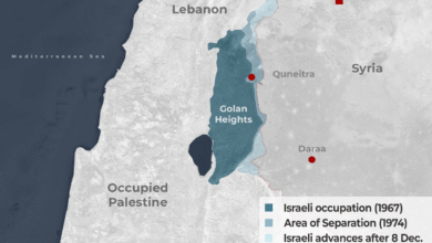
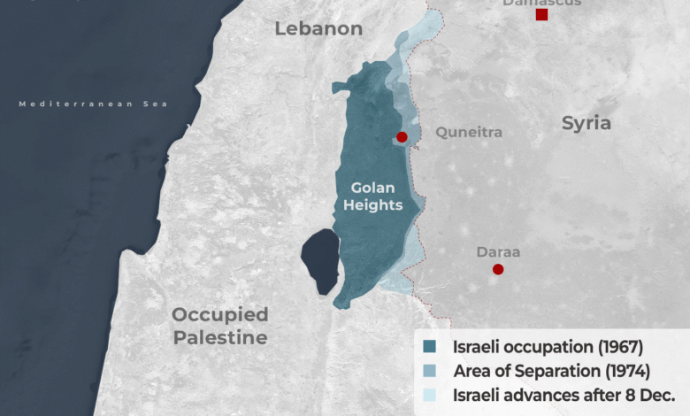
As for geographical borders, From the northern side, the Golan Heights is bordered by the southern and southeastern slopes of Mount Hermon, which constitute its border with Lebanon. It is connected to the west by the Jordan River and Lake Tiberias, which form its border with Palestine. To the south, it is bordered by the lower course of the Yarmouk River, which separates it from the Ajloun Heights and northwestern Jordan. To the east, it is bordered by Wadi al-Raqqad, which forms the administrative border with the governorates of Daraa and Damascus, and the Golan administratively includes three districts: the Golan or Quneitra district, the Zawiya district, and Wadi al-Ajam district.
3- Area :
The area of the Golan Heights is 1,750 square kilometers. It is equal to 1% of the total area of the current Syrian Arab Republic. The plateau extends 74 km from Mount Hermon to the eastern shore of Lake Tiberias. The Golan takes an elongated geometric shape from north to south, extending a distance of 65 km. It is 28 km wide in the center, then narrows to 12 km in the south, and in the north, the width reaches 14 km. The Zionist entity has occupied 1,250 square km of the plateau since the June 1967 war.
Demographic aspect (4 and 5): The population of the Golan in 1967 was estimated at approximately 138 thousand people who lived in 139 villages. After the occupation, a total of 131 thousand people were displaced. Among the displaced were 10 thousand Palestinian refugees who immigrated during the 1948 Nakba and settled in The Golan. In 1967, the Israeli occupation forces destroyed most of the Syrian villages and towns in the Golan Heights. Only six villages located in the far north of the plateau were spared from the barbarism of the occupation and its military machine, which remained inhabited: Majdal Shams, Buqata, Masada, Sahita, Al-Ghajar, and Ain Qanya, which numbered 6,396 citizens. Syrians from the Druze sect did not abandon their homes for three reasons :
1 – Their sheiks issued a religious prohibition against anyone who left his home and fled.
2 – Their villages and homes were not bombed, as were the other villages and towns of the Golan. (Israel) was afraid of the reaction of some of its soldiers and officers from the Druze of Palestine who were loyal to it and who might stand with the members of their sect.
3 – Israel had already begun to draw up a plan to establish a Druze state in 1958, and it needed to win the love of the Druze in these villages so that they would be critical in its relationship with the supposed state. Israel was hoping that the idea of sectarian mini-states would succeed. To be a barrier between it and the Arab depth and to give credibility to its occupation-settlement project also on the basis that this East is fragmented into sectarian divisions and not united in comprehensive political projects. However, this plan failed because the Syrians in the Golan uncovered it and knew the intentions of (Israel) behind it, confirming their full affiliation. Their loyalty to the Syrian Arab Republic and their being an integral part of it.
– The strategic importance of the Golan Heights (6)(7 )
The strategic value of the Golan Heights demonstrated a clear desire among the Israeli political and military leadership for the necessity of controlling this region.
-1 The military aspect :
The Golan has assumed great strategic and military importance, as it constitutes an impregnable natural fortress in cases of war due to biological factors such as mountains and valleys acting as protective shields against military attacks. Therefore, controlling the Golan means the ability to defend and protect it and threaten and occupy its neighboring areas. Quickly and simultaneously, especially in the western regions of Palestine, which are overlooked by the plateau from a high altitude. One Israeli study summarized the strategic and security importance of the Golan Heights in three main points:
The defensive field: because it is the region through which it is easy to defend the settlements of the Jordan Valley and the Eastern Galilee And protect the settlers there.
B- The warning field: The Zionists adhere to their presence on the top of Mount Hermon, which constitutes one of the most essential Israeli observation points. A journalist mentioned this importance: “Every Israeli knows that Mount Hermon is like the eyes of the state, but it is more appropriate to call it the ears of the state and the warning.” A credible person must pick up attack orders when they are issued. From the Mount Hermon area, it is possible to eavesdrop on the Syrian communications network in the Damascus area, especially telegrams and telephone communications. On top of Mount Hermon, Israel has an extensive network of radars, early warning devices, and monitoring and control points that reach deep into Syrian territory.
C- The political field: The Golan is a trump card that can be used politically in upcoming negotiations.